2020 Year in Review
- David O'Brien
- Dec 31, 2020
- 5 min read
Updated: Mar 31, 2021
This year has been incredibly successful for our team at SurvTech! Despite some challenging circumstances, we hit many milestones; one of those being our company reached 100 employees! We'd like to share some other achievements:
New equipment:
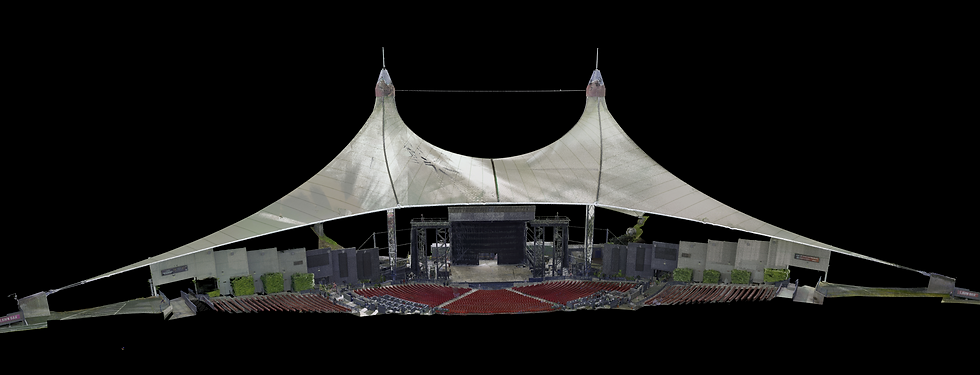
NavVis M6 Indoor Mobile Mapping System
Having provided indoor and outdoor 3D laser scanning services for last few years, we are speeding things up with a new style of mobile scanning specifically designed for larger environments. In addition to collecting 360° immersive imagery, and sensor data at walking speed, the system also includes a new way to manage and share data with NavVis IndoorViewer.
We utilized this scanning system on one of our key projects this year: Scanning the Perfecto Garcia Brothers Cigar Factory
OpenSwap ASV
This year, we added two OpenSwap Autonomous Surface Vessels (ASVs) to our hydrographic survey fleet. These lightweight customizable survey vessels will enable fully autonomous single-beam bathymetry with RTK positioning in waterbodies that are difficult to access. With this addition, we are continuing our trend of expanding our hydrographic toolbox to include the right tool for each unique job.
Galaxy T2000
With this upgrade, SurvTech will increase efficiency of our airborne data collection for a variety of projects in different markets, including but not limited to, wide area capture, national elevation programs, and utility corridors. For the last 16 years, SurvTech Solutions has been supporting federal, local government and private industry with high-quality geospatial products.
PhaseOne iXU
We recently added a PhaseOne iXU 1000 RGB medium format camera (100 MP) operating with our Optech Galaxy T2000. This metric camera is able to acquire high resolution imagery concurrently with LiDAR data for different mapping applications from utility corridors, roadway and wide area mapping. The ability to collect LiDAR and Imagery in a single flight mission translates into savings for our clients. The PhaseOne camera is well suited for photogrammetric mapping and ortho image production offering our clients.
The Snoopy-Riegl VUX1-UAV was added to our fleet of UAV LiDAR sensors to help the efficiency of our field collection and data processing conducted in-office. The VUX1-UAV is the top of the line when it comes to UAV LiDAR sensors, enabling us to fly at 400’ while collecting data where previously we were limited to nearly half of that altitude. Two of the biggest advantages this presents to us is the ability to collect LiDAR data in environments we were unable to utilizing our other LiDAR sensor (such as areas with tall electrical transmission poles or obstacles combined with terrain/elevation changes), as well as the ability to collect a much larger area in less time due to the height advantage.
DJI Matrice 300
The UAS department also added to its fleet of unmanned systems by purchasing a DJI Matrice 300 paired with a Zenmuse H20T camera. The M300 is the latest in drone technology, offering safety components and advanced features that will increase our effectiveness in inspections and photogrammetry projects. The Zenmuse H20T is a quad-sensor, providing both a 20 MP zoom camera and a 12 MP wide-angle camera as well as a radiometric thermal camera, which we plan to utilize in various inspections where thermal detection is necessary. This addition to the UAS department will allow us to expand our offerings in the new year, to broaden the extent of our capabilities and increase the quality of work we are able to provide our clients.
Leica AT 403 and Leica AT 960-LR
In 2020, SurvTech added a new service offering: Metrology. Metrology is performing extremely precise measurements, in the realm of 1/10,000th of an inch precision. To perform this type of work, we purchased a Leica AT (Absolute Tracker) 403, a Leica AT 960-LR, and the Spatial Analyzer software suite. With this equipment, SurvTech has monitored bridges, aligned industrial equipment, and performed precision layout on numerous industrial sites.
Leica RTC360
With two new Leica RTC360 scanners, SurvTech will be able to scan 4-5 times faster than with our previous scanners. This means much higher efficiency in the field without compromising accuracy or point cloud density. With the RTC360s, we can scan everything quicker and save valuable time due to the on-board photogrammetry and IMU that allows the scans to be registered while you perform your field work. The Visual Inertial System (VIS Technology) automatically tracks the scanner movement from station to station while you are on-site, leading to an automatic pre-registration directly in the field and on a mobile device. This process extensively cuts the time from field to final registration.
Proceq GP8800 and Proceq GP8000
Our Subsurface Utility Engineering (SUE) department recently added the Proceq GP8800 and Proceq GP8000 for concrete inspection and imaging. Both tools provide a portable capability for detecting underground objects in obstructed or congested spaces with unparalleled accuracy and precision.
Conferences and Events:
Robofest Regional Competitions
SurvTech had the privilege of joining the 13th Robofest Regional Qualifying competition on March 7th in Oldsmar, Florida. Robofest is a festival of competitions and events with autonomous robots that encourages students to have fun while learning principles of Science, Technology, Engineering, and Math (STEM) and Computer Science.
Environmental Permitting Summer School
SurvTech exhibited at the 34th Annual Environmental Permitting Summer School. Hosted by the Florida Environmental Network, Inc, part of the Florida Chamber Foundation, this event is attended by hundreds of professionals involved with environmental regulation in Florida. Each year, they gather in Marco Island to receive instruction by leaders in the environmental industry, explaining the latest in regulatory changes and highlighting new methods of conducting environmental survey in support of permitting compliance.
Florida Industrial and Phosphate Research Institute
SurvTech president David O’Brien and UAV (Unmanned Aerial Vehicle) department manager Mark Bickel presented at FIPR (Florida Industrial and Phosphate Research) to a Florida Polytechnic class on UAV mapping. The institute is part of Florida Polytechnic University, and they have been granted the opportunity to launch a UAV program within the institute. The primary goal of the institute is to give the students hands-on experience with UAVs, specifically in the areas of photogrammetric and LiDAR mapping.
New offices:
The Lakeland office began operating at the beginning of 2020 to strengthen our presence in Central Florida, and many of our clients will benefit from the convenient location of this office. This division is led by Professional Surveyor and Mapper, Tim McClintic. Coming from our headquarters in Tampa, Tim is one of our most tenured team members at SurvTech Solutions. The Lakeland location is now the base of operations for the unmanned aerial vehicle (UAV) department, which mobilizes to all of Florida and the Southeast United States.
The Boise office is lead by former Idaho resident, Corey Myllenbeck. One of SurvTech’s fastest growing departments specializes in subsurface utility location, designation, and mapping. Commonly known as “SUE,” Subsurface Utility Engineering is a specialized form of mapping that provides much needed information for those looking to design, dig, or otherwise break ground.
New UAV Department Head
Mark Bickel was added as the new head of our Unmanned Aerial Systems (UAS) department. As one of our technical survey departments, the UAS team operates Unmanned Aerial Vehicles (UAVs), also known as “drones,” to collect a variety of survey products.
We would like to thank our amazing clients and team members that made this year so successful. We are looking forward to next year!