

Utilizing the Leica RTC360: Capture of Shoreline Tensioned Membrane Roof Structures
- Caitlin Glazewski
- May 5
- 2 min read
Updated: May 7
SurvTech Solutions combines surveying knowledge and detail -oriented approach to provide services focused on delivering reliable information that project teams can use to manage risk, protect assets, and maintain control of complex projects.

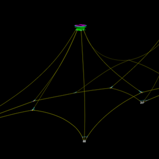
End-to-End Reality Capture of a Tensioned Membrane Roof
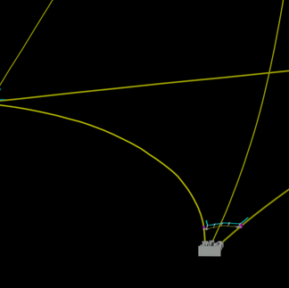
This past month, SurvTech successfully utilized the Leica RTC 360 laser scanner to capture critical structural components of the tensioned membrane roof at the Shoreline Amphitheater outdoor venue in Mountain View, California. Focusing on weldments, cable systems and tie points to develop an accurate 3D model for engineering analysis.
Given the complexity of the tensile membrane roof structure and the challenge of the environment, a scan to model workflow was implemented to prioritize internal accuracy and complete geometric representation with limited survey control.

Optimized Scan Planning & High-Accuracy Data Processing
Strategic scan planning and positioning ensured a full coverage of connection points, cable paths, and anchorage locations. While multiple scan angles and high overlap between setups minimized occlusions and supported precise cloud-to-cloud registration. The RTC360's integrated Visual Inertial Systems (VIS) enabled efficient field acquisition and real time validation of scan completeness, allowing field crews to confirm data quality prior to demobilization.
Post- processing In Leica Cyclone REGISTER 360 included iterative registration refinement, noise reduction, and segmentation of key structural elements, ensuring a clean and reliable dataset.

Point Cloud Conversion to 3D Model
The resulting point cloud was then used to generate a detailed 3D model in TopoDot, accurately representing weld geometries, cable routing, and tie-in locations. This workflow provided a high resolution digital representation of the structure, enabling engineers to perform detailed assessments and plan modifications with confidence. The project highlights how efficient reality capture methods combined with disciplined field practices and quality control can deliver precise and actionable data for complex structural systems, even in environments where traditional measurement methods are limited.


Get Accurate 3D Models of Your Project
If you are looking for the highest level of professionalism and accurate data with efficient surveyors that are ready to embrace the cutting edge of surveying technology, then 3D Laser Scanning from SurvTech Solutions is the choice for your next project and for your firm.