

MacDill AFB LiDAR Project
- David O'Brien
- Sep 12, 2022
- 4 min read
Updated: Feb 6, 2023
As many of you know, SurvTech performs aerial LiDAR from all platforms, including planes, UAVs, boats, trucks, UTVs, and even tripods. At SurvTech, we always endeavor to present our clients with the correct solution for their projects. One such example was a project at MacDill Air Force Base (MacDill), where environmental restoration was performed by Ecosphere, a nonprofit restoration organization. See (Figures 1 & 2) for a look at what the original landscape looked like before the construction of the mosquito ditches.


Ecosphere has contracted with MacDill to remove spoil mounds associated with widespread mosquito ditching practices. The spoils consisted of hundreds of piles throughout the project area. The problem was that these mosquito ditches were at the south end of MacDill, basically at the end of the base’s runway. Not only are they in a very restricted area, but they are also highly overgrown with mangroves. For the restoration project, it was essential to calculate the volumes of the existing spoil piles, not the ditches. The ditches all have water in them, so LiDAR would not have been a solution for any subaqueous data, but for the spoil piles, LiDAR could be an option if it could penetrate the mangroves. Due to the vegetation and site conditions (some of the largest mosquitos my field crews have ever witnessed), surveying the mounds with conventional surveying is highly tedious and time-consuming. If a survey crew investigates these piles, the data density (number of spot elevations) is limited. When calculating volumes, your results are only as accurate as your dataset so a sparse dataset can leave a lot of guesswork in the volume calculations. See the level of vegetation in the unfiltered LiDAR data (Figure 3), then look at the amount of data that penetrated the vegetation to the bare earth (Figure 4).


The client had already tried using open-source LiDAR for volumetric calculations but had poor results. The vegetation (mangroves) was just too thick for LiDAR, which was only 3-4 points per square meter (PPSM) in open terrain, never mind a densely vegetated site. SurvTech consulted with Ecosphere and informed them that LiDAR technology was not the problem. It was the LiDAR acquisition platform that was the problem. LiDAR from an airplane would not give the end user the data density required to penetrate the thick vegetation. However, LiDAR data from a UAV equipped with a high-end LiDAR sensor flying slow at a low altitude and acquiring data in a cross-hatched pattern could yield data with a density of hundreds of PPSM.
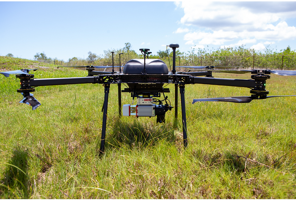
It would be challenging to get approval to fly a commercial UAS (unmanned aerial system) in that area on time, so we decided to pool our resources and bring in the U.S. Army Engineer Research and Development Center (ERDC) Environmental Laboratory UAS group to our team for data acquisition. They confirmed they would have no problem acquiring LiDAR data from a UAV at MacDill AFB in coordination with base personnel. So, with ERDC personnel performing the acquisition and providing the raw LiDAR data to SurvTech for processing, we had a roadmap to performing a UAV LiDAR project at MacDill. SurvTech and ERDC personnel coordinated their site visit, with SurvTech providing ground control for the LiDAR and ERDC personnel performing the LiDAR acquisition with a Harris Aerial Hx8 heavy lift UAV and a Riegl miniVUXII LiDAR sensor (Figure 5). The addition was seamless, with ERDC personnel flying a cross-hatched pattern for greater data density. They flew only two missions and acquired approximately 270 PPSM, which is incredible data density. The raw data was delivered to SurvTech personnel on site and sent to our LiDAR group for post-processing. SurvTech’s LiDAR department went to work. The LiDAR data was processed and calibrated. Then SurvTech personnel used aggressive automatic vegetation filtering and manual class verification to create a bare earth model. After filtering the dataset, there was still approximately 10 PPSM, which is not extremely high but much better than a few survey spot elevations taken over a given area.

SurvTech’s LiDAR group performed quality control and assurance (QA/QC) on the dataset, checking control stations and calibration points. The standard deviation for the LiDAR data was 0.076 feet, which is well within the tolerance of accuracy we would achieve with RTK GPS and more than enough accuracy for earthwork calculations. After the data accuracy was verified, volumes were calculated for each pile above a set elevation. A digital elevation model (DEM) (Figure 6) was shipped to SurvTech’s surveying department. A DTM (digital terrain model) with contours (Figure7) was created, a topographic contour map was drafted, and secondary volumetric calculations were produced. SurvTech performs volumetric calculations almost daily, and we always perform these calculations with multiple surfaces and software platforms to ensure data integrity. The topographic map with volumetric calculations was drafted, certified, and delivered to Ecosphere for use in construction estimating of the environmental restoration work. Figure 4 are images of the bare earth LiDAR data after being manipulated into DEMs and contours.

This project exemplifies SurvTech’s ability to offer our clients innovative solutions to any problem. By working with a government agency in a public-private partnership, we delivered our client the most accurate and highest quality solution. Accurate data and the associated volumetric calculations enable Ecosphere to predict construction estimates more accurately for their restoration projects, enabling fewer change orders or schedule interruptions. Accurate data becomes the foundation of a successful environmental restoration project at MacDill.


